Drones are everywhere. From capturing breathtaking sights to their usage in law enforcement, there is hardly a field that is left untouched by these man-made marvels. And one of the biggest contributors to these is the LiDAR drones.
LiDAR-equipped drones are revolutionizing the way we gather and analyze spatial data. From construction to archeology, their use is as varied as they come. But how much does a LiDAR drone cost? And is the LiDAR drone price really worth it? Let’s uncover these.
An Overview of the LiDAR Technology
But before we go discussing the LiDAR drone price, let’s first understand what LiDAR technology is.
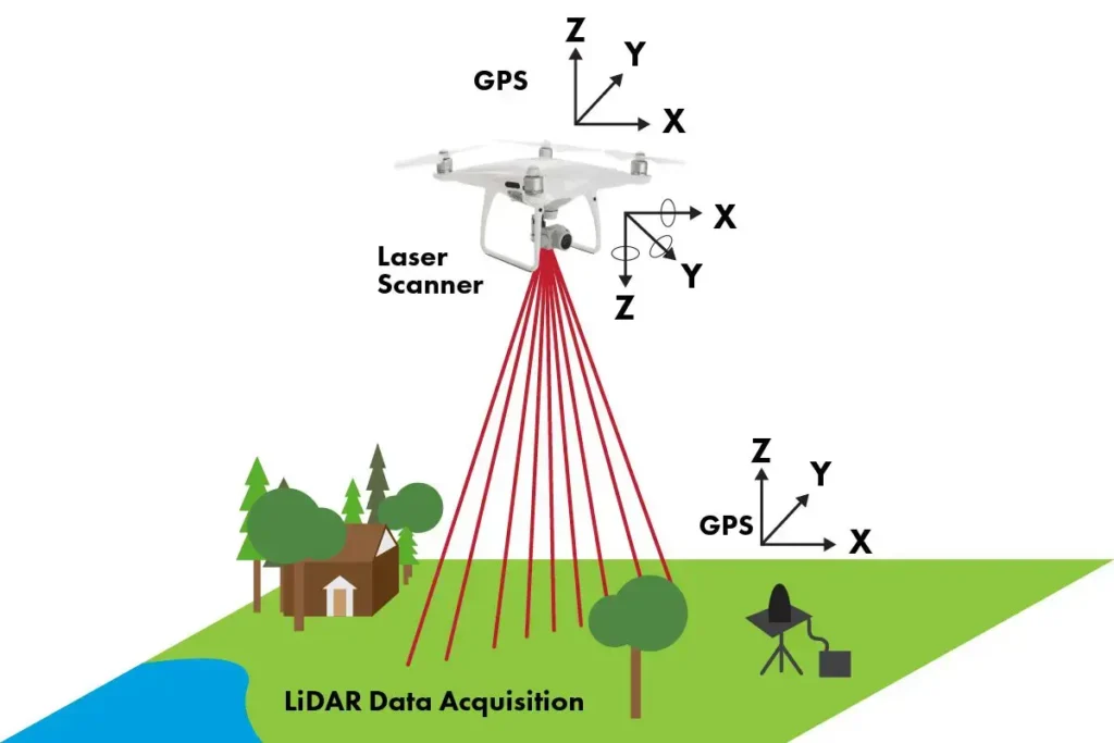
LiDAR stands for Light Detection and Ranging and is a cutting-edge remote sensing method that uses laser light to measure the Earth’s surface. What this does is that it helps drones create detailed and highly accurate three-dimensional maps of terrain and objects.
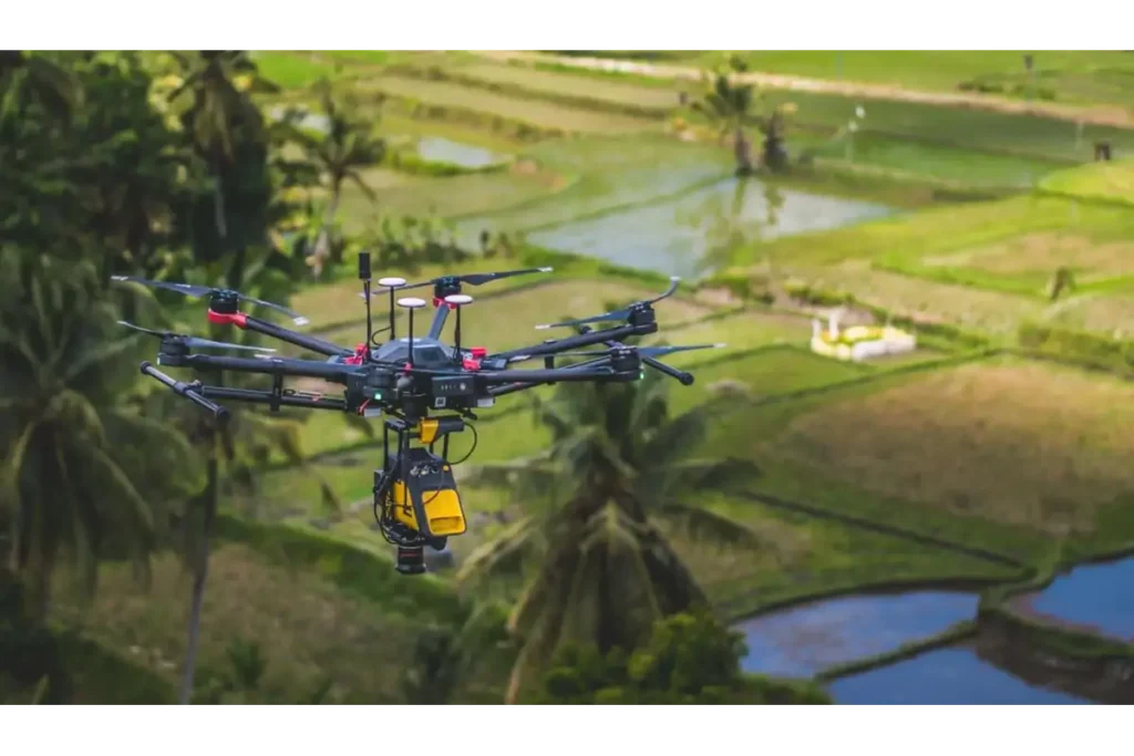
Image Credit: Flyguys
LiDAR tech is also extremely precise, something that is due to the ability to emit light pulses and measure the time taken for these pulses to bounce back after hitting an object or the sound. So, something similar to SONAR technology used in submarines, but a lot faster. This time-of-flight information, combined with the position and angle of the LiDAR system, is used to calculate accurate geographical points, creating a detailed 3D representation of the surveyed area.
Factors that impact the LiDAR Drone cost
The cost of LiDAR can vary significantly. Here are some of the factors that determine how much a LiDAR drone costs:
Type of Drone
It would not surprise you to learn that LiDAR drones come in different forms, including fixed-wing, multirotor, and hybrid models, and not all of these drones are priced the same. The complexity and capabilities of these drones greatly influence their price.
Flight Time and Payload Capacity
Longer Flight Times allow the drones to cover a larger area in a single flight and, at the same time, reduce the number of flights needed for a project. Payload capacity is also crucial as it determines the weight of LiDAR sensors the drone can carry without affecting its performance. So, the next time you ask why the LiDAR drone survey cost is a bit high, this is the answer.
GPS Accuracy and Stability
High-precision GPS and stable flight capabilities are essential for accurate data collection, which certainly adds to the cost of the drone.
Cost Factors for LiDAR Services
Terrain and accessibility
The area where the drone has to operate plays a significant part in the cost of LiDAR services. Difficult terrains like mountains or wetlands can increase operational complexity, and so can the cost of the service.
Service Range
The service costs typically range from $6500 to $9000 per day, but it can also go up to $12000, depending on the specific requirements. You might qualify for discounts if you have high-volume or multi-day projects.
File Type and Data Processing
Finally, you might need the files in specialized types, which also impacts the cost. File types such as .DWG files, contour lines, and digital models will add to the service cost.
Additional Costs and Considerations
Beyond the initial purchase and service, there are other additional costs that you need to take into account.
Software and Maintenance
You might need specialized software for data processing. You would also need to ensure regular upkeep of your drone and the sensors it uses.
Training and Operational Costs
Training for personnel to operate these advanced systems and ongoing operational expenses can also contribute to the overall cost.
How much is a LiDAR Drone?
Image Credit: Routescene
We have covered what LiDAR technology is, why it is useful, and the factors that impact the price of LiDAR drones and services. The only thing that remains is the question this whole post is about: how much does a LiDAR drone cost?
Entry-level systems, which are suitable for basic surveying tasks, can start from around $25,000 to $50,000. These systems are equipped with less sophisticated sensors and have limited range and accuracy.
Mid-range models, with better accuracy and functionality, cost somewhere around $50,000 to $150,000.
For high-end, professional-grade LiDAR drones, the price can easily exceed $150,000. These models are usually employed in complex projects like detailed geographical surveys and advanced research.
Yes, you can easily purchase drones equipped with LiDAR sensors, though they can be more expensive than the average drones you will find on Amazon. These drones are typically high-end, professional-grade drones used for precise mapping, surveying, and data collection.
The range of a LiDAR drone refers to the maximum distance it can effectively measure from a location. This is something that varies based on the sensor’s capabilities and the drone’s design. Typically, a LiDAR drone has a range from a few meters to several miles.
The best entry-level LiDAR drone often depends on what exactly what you need it for. The most popular entry-level LiDAR drone in the market is the DJI Phantom 4 RTK. Just make sure that the model you opt for has a compatible LiDAR sensor attached.
Nothing is 100% accurate; however, the accuracy of LiDAR drones is exceptionally high. But you should keep in mind that the accuracy of the LiDAR depends on multiple factors; these are:
A DJI drone equipped with a LiDAR sensor is typically priced in a range between $20,000 to over $100,000. Naturally, if you go with high-end configurations, especially those used for complex professional applications, the drones would be at the higher end of the price spectrum.
Conclusion
It goes without saying that the LiDAR technology, with its groundbreaking precision in mapping and surveying, is changing the drone industry every day. This transformative tool has made it possible for drones to be used across numerous industries. And while the initial investment in a LiDAR-supported drone can be substantial, the value it brings to the table is unparalleled.
Why trust Brownspace?
At Brownspace, we write about what matters most to the audience. We do well-researched work to provide in-depth knowledge of drones. Additionally, we interview people using drones to ensure the credibility of the drones used and offer real-life user experience to our readers.
Hi, drone enthusiasts! Born with a natural curiosity for the skies, I developed a love for drones early in life. I began flying drones in 2017 and have since piloted some of the best drones available, such as the Yuneec Typhoon, DJI Mini, Mavic Pro, Hover Camera, and Phantom 3. With passion for drones and expertise gained over the years, I would love to share my knowledge of drones at Brownspace. Stay tuned for an insider’s perspective about drones.
The views and opinions expressed on this website are our own and are based on our experiences. This website contains affiliate links. We only recommend products that we genuinely believe will add value to our audience. The decision to buy the product entirely depends on you.